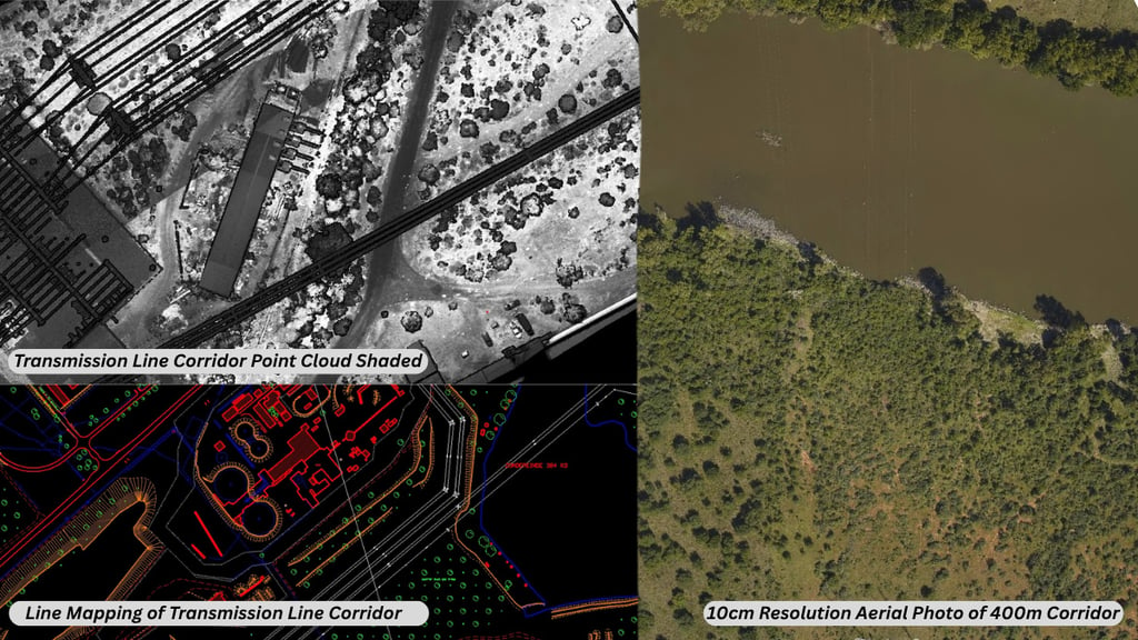
Corridor mapping is the process of capturing accurate survey and mapping data along a defined linear route. This route may be a powerline, pipeline, road, railway, transmission corridor, access road or future infrastructure alignment.
For infrastructure, energy, utilities, mining and development projects, corridor mapping helps project teams understand the land before planning, designing or building. It provides the spatial data needed to assess terrain, elevation, vegetation, access constraints, route risks and surrounding features.
When corridor mapping is done using aerial LiDAR, large areas and long routes can be captured quickly and accurately. This makes it especially useful for projects that cover long distances, cross difficult terrain or require engineering-grade survey information.
BB Aerial Surveyors provides Corridor Mapping and fixed-wing aerial LiDAR survey solutions for infrastructure, energy, mining, environmental and development projects across Southern Africa.
What is corridor mapping?
Corridor mapping focuses on a specific route or linear area instead of a general site.
This can include:
Powerline corridors
Transmission line routes
Pipeline routes
Road corridors
Railway corridors
Water pipeline routes
Utility servitudes
Access roads
Proposed infrastructure alignments
The purpose is to create accurate mapping data that helps engineers, planners, developers and project teams understand what exists along the route and what may affect the project.
Why corridor mapping is important?
Infrastructure routes often pass through changing terrain, vegetation, rivers, roads, settlements, farms, slopes, servitudes and existing infrastructure.
Without accurate survey data, project teams may face problems such as:
Poor route alignment decisions
Unexpected terrain challenges
Access difficulties
Incorrect elevation assumptions
Vegetation clearance issues
Delays during design or construction
Incomplete understanding of site conditions
Higher project risk
Corridor mapping helps reduce these uncertainties by giving the project team a clearer view of the route before major decisions are made.
How does aerial LiDAR supports corridor mapping?
Aerial LiDAR uses laser-based scanning to capture accurate 3D data of the ground and surrounding features. When mounted on an aircraft, LiDAR can capture long corridors efficiently and at scale.
This is especially useful when the route is:
Long
Remote
Difficult to access
Covered by vegetation
Spread across uneven terrain
Time-sensitive
Located across multiple properties
Part of a larger infrastructure development
For corridor projects, aerial LiDAR helps provide reliable data for planning, feasibility, design and risk assessment.
Corridor mapping for powerlines and transmission routes.
Powerline and transmission corridor projects often require accurate information about terrain, vegetation, route alignment, clearances and surrounding infrastructure.
Aerial LiDAR corridor mapping can support:
Transmission line planning
Powerline route assessment
Vegetation and encroachment analysis
Tower position planning
Access route planning
Terrain and elevation modelling
Existing infrastructure identification
Corridor condition assessment
For energy and utility projects, accurate corridor data can help teams plan with more confidence and reduce avoidable design or construction challenges.
Corridor mapping for pipelines.
Pipeline routes can cross complex environments, including farms, rivers, wetlands, roads, settlements, slopes and existing services.
Corridor mapping can support pipeline projects by helping teams assess:
Terrain conditions
Elevation changes
Route feasibility
River and drainage crossings
Access routes
Environmental constraints
Existing infrastructure
Construction risk areas
This information is useful during early planning, route selection, environmental review and engineering design.
Corridor mapping for roads and rail.
Road and rail projects depend heavily on accurate terrain and alignment data. Even small errors in elevation or route understanding can affect design decisions.
Aerial LiDAR corridor mapping can assist with:
Road alignment planning
Rail route assessment
Slope and terrain analysis
Bridge and crossing identification
Drainage planning
Earthworks estimation
Access planning
Design support
For transport infrastructure, corridor mapping provides the spatial foundation needed to evaluate route options and reduce planning uncertainty.
What data can be delivered from a corridor mapping project?
The exact deliverables depend on the project requirements, but corridor mapping can produce a range of useful outputs.
These may include:
LiDAR point cloud data
Digital terrain models
Digital surface models
Contour data
Orthophotos
Corridor imagery
GIS-ready datasets
Route alignment data
Elevation profiles
Vegetation and surface feature data
Engineering-grade survey outputs
3D corridor models
These deliverables help engineers, planners and project teams work from reliable spatial data instead of outdated maps or assumptions.
When should corridor mapping be done?
Corridor mapping is most valuable early in a project, before final route decisions and detailed design work are completed.
It is useful during:
Feasibility studies
Route selection
Tender preparation
Environmental planning
Engineering design
Construction planning
Asset management
Corridor monitoring
By capturing accurate data early, project teams can identify potential issues before they become expensive problems.
Who uses corridor mapping data?
Corridor mapping data is commonly used by:
Engineering consultants
Utility companies
Renewable energy developers
Mining companies
EPC contractors
Municipal infrastructure teams
Environmental consultants
Road and rail project teams
Project managers
GIS specialists
Each team may use the data differently, but the goal is usually the same: better route understanding, better planning and better project decisions.
Why fixed-wing aerial LiDAR is useful for long corridors?
Fixed-wing aerial LiDAR is well suited to long-distance corridor mapping because it can cover large areas efficiently.
This makes it valuable for:
Long powerline routes
Regional infrastructure corridors
Pipeline alignments
Road and rail networks
Remote or difficult terrain
Large-area project planning
For projects where distance, scale and terrain complexity matter, fixed-wing aerial LiDAR can provide a practical and efficient survey solution.
Frequently Asked Questions
What is corridor mapping used for?
Corridor mapping is used to capture accurate survey and mapping data along a defined route, such as a powerline, pipeline, road, railway or infrastructure corridor.
Is corridor mapping useful for transmission lines?
Yes. Corridor mapping is useful for transmission line planning, vegetation assessment, terrain modelling, access planning and route design support.
Can aerial LiDAR be used for pipeline route planning?
Yes. Aerial LiDAR can help pipeline project teams understand terrain, elevation, drainage, access routes and potential constraints along a proposed route.
What is the difference between corridor mapping and site mapping?
Site mapping usually focuses on a defined area or property. Corridor mapping focuses on a long, narrow route or alignment.
What information is needed before requesting a corridor mapping quote?
Useful information includes the route location, approximate corridor length, corridor width, required deliverables, accuracy requirements, project timeline and intended use of the data.
When is the best time to do corridor mapping?
Corridor mapping is most valuable during early planning, feasibility, route selection and design stages, before major project decisions are finalised.
Need accurate corridor data for your next project?
BB Aerial Surveyors provides fixed-wing LiDAR and aerial mapping solutions for corridor, infrastructure, energy, mining, environmental and development projects across Southern Africa.
If your project involves a powerline, pipeline, road, rail route or infrastructure corridor, accurate aerial survey data can help your team plan with greater confidence.
Contact BB Aerial Surveyors to discuss your corridor mapping project.
Contact Us
info@bbaerialsurveyors.co.za
+27-82-852-4309
© 2026 BB Aerial Surveys (Pty) Ltd. All Rights Reserved | Website designed and developed by Creative Co-Pilot — Guiding brands from idea to launch, and beyond.
LiDAR You Can Build On
Serving South Africa & Pan-Africa
Build Smarter With LiDAR
Get expert LiDAR updates, case studies, and project insights straight to your inbox.