
USE CASE | ENERGY & UTILITIES
Transmission Corridor Mapping
Supporting route selection, feasibility, and early design with fixed-wing LiDAR.
Transmission and other linear infrastructure projects require reliable corridor data across long distances, varied terrain, and multiple environmental and engineering constraints. BB Aerial Surveyors supports these projects with fixed-wing LiDAR corridor mapping and decision-ready spatial outputs that help teams compare route options, understand terrain and access conditions, and move into feasibility and early design with greater confidence.
INDUSTRY
SERVICE APPLIED
Energy & Utilities
Linear Infrastructure
Corridor Mapping
DECISION MAKER
Utility Developers
Consulting Engineers
Route Planners
EPC Contractors
Infrastructure Asset Owners
Enviromental Teams
Approval Teams
BEST FIT APPLICATIONS
Utility Corridor Development
Pipeline Route Assessment
Road and Rail Corridor Studies
Long-distance Infrastructure Feasibility
Corridor Planning in Remote, Vegetated, or Access-Constrained Terrain
The Challenge
Transmission corridor projects require more than broad topographic awareness. Project teams need to compare route alternatives, understand terrain and slope conditions, identify river and wetland crossings, access for construction and maintenance, and avoid environmental and geotechnical constraints early enough to support feasibility and preliminary design. Practical considerations such as route length, minimizing bends, access for heavy vehicles and cranes, and using existing infrastructure corridors where possible are important parts of transmission line routing in South Africa.
Traditional ground-only surveying across long linear routes can be slow, fragmented, and difficult to scale consistently. Where data is incomplete, outdated, or not structured for corridor comparison, project teams may struggle to evaluate alternatives properly, understand terrain constraints, or align engineering, environmental, and approval workstreams around the same spatial picture.
For corridor-based infrastructure, the real challenge is not simply collecting data. It is obtaining reliable corridor intelligence at the right scale, in the right format, and with enough consistency to support route selection, feasibility studies, environmental screening, and preliminary design.
THE SOLUTIONS CAN COMBINE
Fixed-wing LiDAR acquisition for broad corridor coverage
Orthophotos for visual context
Terrain modelling for slope and landform interpretation
GIS-ready datasets for planning and environmental workflows
Engineering-ready mapping outputs for technical teams
Ground survey support where required for control or targeted site inputs
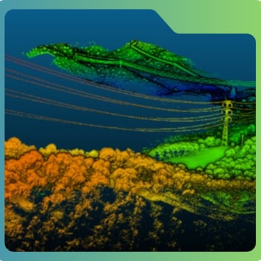
LiDAR point clouds can be classified into terrain, vegetation, buildings, water, and other features, and then processed into bare-earth models such as DTMs.
That makes the data especially useful where terrain needs to be understood beneath vegetation cover or across large, difficult-to-access corridors.
Project Teams get more consistent spacial base for:
Route alternative comparison
Terrain and crossing assessment
Corridor profiling
Environmental screening
Preliminary engineering interpretation
Why It Matters
BB Aerial Surveyors applies fixed-wing LiDAR corridor mapping to capture high-precision spatial data efficiently across long transmission and infrastructure routes.
This approach is designed to support corridor-wide visibility and provide a stronger technical foundation for route selection, feasibility, and early design.
Our Solution
When corridor data is incomplete or poorly structured, projects can face:
slower route-option comparison
weaker confidence in early planning decisions
more uncertainty around terrain, access, and crossings
duplicated or repeated field investigations
avoidable redesign later in the project
weaker coordination between engineers, planners, GIS teams, and environmental specialists
Deliverables
Results & Impact
Why BB Aerial Surveyors
classified LiDAR point cloud
high-resolution orthophotos
digital terrain model (DTM)
digital surface model (DSM)
contours
3D terrain data
corridor centreline or route-option mapping
crossing and constraint mapping
GIS-ready layers
engineering-ready spatial outputs
project-specific reporting packs
better route-option comparison
improved visibility of terrain and corridor constraints
stronger confidence in feasibility and preliminary design
reduced reliance on fragmented, repeated field mobilisation
better alignment between engineering and environmental workstreams
more defensible early planning decisions
BB Aerial Surveyors brings fixed-wing LiDAR capability, large-area coverage, engineering-grade outputs, and practical project understanding to corridor-based infrastructure work.
The value is not just in capturing data, but in delivering usable, decision-ready spatial information that supports planning, feasibility, and early design.
Terrain information is used both to evaluate alternative routes and inform later design work, better spatial data at the start of a project can reduce uncertainty throughout the project lifecycle.
FAQs
What is transmission corridor mapping?
It is the capture and structuring of spatial data along a proposed or existing linear route to support planning, alignment, and design decisions.
Why is LiDAR useful for corridor mapping?
It helps capture detailed terrain and surface information efficiently over long distances.
When is fixed-wing LiDAR the right choice?
It is especially useful for long linear projects that need broad, consistent coverage.
Can LiDAR help identify river, wetland, and terrain constraints along a corridor?
Yes. LiDAR-derived terrain models and spatial datasets can help teams understand slope, landform, crossings, and environmentally sensitive areas earlier in the routeing process.
What deliverables are typically provided?
Point clouds, orthophotos, terrain models, contours, corridor datasets, and GIS-ready outputs.
Can corridor mapping support both route selection and later design stages?
Yes, but required outputs and detail may vary by project phase. Early routing and feasibility focus on corridor-wide constraints and terrain understanding, while later stages may require more detailed engineering or site-specific survey inputs.
Plan your corridor with better data from the start.
Speak to BB Aerial Surveyors about transmission corridor mapping for your next utility or infrastructure project.
Contact Us
info@bbaerialsurveyors.co.za
+27-82-852-4309
© 2026 BB Aerial Surveys (Pty) Ltd. All Rights Reserved | Website designed and developed by Creative Co-Pilot — Guiding brands from idea to launch, and beyond.
LiDAR You Can Build On
Serving South Africa & Pan-Africa
Build Smarter With LiDAR
Get expert LiDAR updates, case studies, and project insights straight to your inbox.