Fixed-Wing LiDAR vs Drone Surveying: Which Is Right for Your Project?

Fixed-wing LiDAR and drone surveying are both valuable aerial mapping methods, but they are not always used for the same type of project.
The right choice depends on the size of the survey area, the required data, the terrain, the project timeline, the level of accuracy needed and the final deliverables required by the project team.
For engineering, infrastructure, mining, environmental and development projects, choosing the right survey method early can help reduce delays, improve planning and provide better data for decision-making.
BB Aerial Surveyors provides fixed-wing LiDAR surveys and aerial mapping solutions for large-area, corridor, infrastructure, mining, agricultural and environmental projects across Southern Africa.
What is fixed-wing LiDAR surveying?
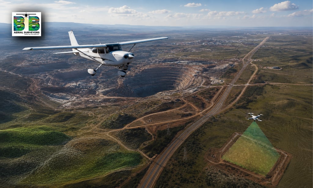
Fixed-wing LiDAR surveying uses an aircraft fitted with LiDAR survey equipment to capture accurate mapping data over large areas or long routes.
LiDAR stands for Light Detection and Ranging. It uses laser pulses to measure distances and create detailed 3D information about the ground, terrain, vegetation and surface features.
Fixed-wing LiDAR is especially useful where the survey area is large, remote, difficult to access or spread across long distances.
It is often used for:
Corridor mapping
Powerline and transmission routes
Pipeline routes
Roads and rail corridors
Mining and volumetric surveys
Large infrastructure projects
Environmental and land-use mapping
Route selection and feasibility studies
Regional terrain modelling
What is drone surveying?
Drone surveying uses an unmanned aerial vehicle to capture imagery, video or survey data over a specific area.
Drone surveys are often useful for smaller sites, inspections, construction progress monitoring and visual documentation.
Depending on the equipment used, drones can capture aerial photographs, photogrammetry data or LiDAR data. However, drone surveying is generally better suited to smaller areas or site-specific work compared to fixed-wing aircraft surveys.
Drone surveying is often used for:
Small development sites
Construction progress checks
Roof or structure inspections
Localised mapping
Short survey areas
Visual site updates
Smaller stockpile areas
Detailed low-altitude imagery
The simple difference.
The easiest way to understand the difference is this:
Drone surveying is often useful for smaller, localised sites.
Fixed-wing LiDAR is usually better for larger areas, longer corridors and projects where speed, scale and wide-area coverage matter.
Both methods can be valuable. The best option depends on what your project needs to achieve.
When is fixed-wing LiDAR usually the better choice?
Fixed-wing LiDAR is usually the better option when the survey area is too large, too long or too complex for efficient drone-based capture.
It is especially useful when the project involves:
Long powerline corridors
Transmission routes
Pipeline alignments
Roads and highways
Rail routes
Large mining areas
Open terrain
Remote or difficult access areas
Large agricultural or environmental areas
Regional infrastructure planning
For these projects, fixed-wing LiDAR can capture large areas efficiently while producing detailed mapping data for planning, design and analysis.
When may drone surveying be the better choice?
Drone surveying may be the better option when the project area is smaller, more localised or requires frequent visual updates.
Drone surveying can be useful for:
Small construction sites
Building inspections
Localised terrain mapping
Short-term site monitoring
Visual progress reports
Small stockpiles
Areas where very low-altitude imagery is required
In many cases, drone surveying is practical for smaller projects where the area is easy to access and the required coverage is limited.
Comparing fixed-wing LiDAR and drone surveying.
Fixed-wing LiDAR and drone surveying can both provide valuable aerial mapping data, but they are suited to different project types.
Fixed-wing LiDAR is usually better suited to large areas and long corridors.
It is often used for infrastructure routes, powerlines, pipelines, roads, rail, mining areas, regional terrain mapping and projects where speed, scale and wide-area coverage are important.
Drone surveying is usually better suited to smaller sites and localised work.
It is often used for construction progress checks, small site mapping, inspections, visual documentation and areas where low-altitude imagery is useful.
When it comes to coverage, fixed-wing LiDAR can capture larger areas and longer distances more efficiently. Drone surveying is more limited per flight, but can be practical for compact sites.
When it comes to project scale, fixed-wing LiDAR is useful for long-distance and large-area projects. Drone surveying is useful when the work area is smaller, clearly defined and easy to access.
When it comes to terrain, fixed-wing LiDAR is often better suited to remote, difficult or uneven terrain. Drone surveying works well where the site is accessible and flight conditions are manageable.
When it comes to deliverables, fixed-wing LiDAR can provide outputs such as LiDAR point clouds, digital terrain models, contours, orthophotos, GIS-ready data and engineering-grade survey outputs. Drone surveying can provide imagery, photogrammetry data, video, inspection records and localised mapping outputs, depending on the equipment used.
The simple way to decide is this:
Use fixed-wing LiDAR when the project needs speed, scale, long-distance coverage or engineering-grade terrain data.
Use drone surveying when the project is smaller, site-specific, inspection-focused or mainly requires localised visual information.
Fixed-wing LiDAR for corridor projects.
Corridor projects often require accurate mapping over long, narrow routes. These routes may include powerlines, pipelines, roads, railways, access roads or utility servitudes.
For corridor projects, fixed-wing LiDAR can help capture:
Terrain data
Elevation profiles
Vegetation data
Surface features
Route alignment information
Access constraints
Existing infrastructure
GIS-ready corridor data
This makes fixed-wing LiDAR especially valuable for long-distance infrastructure and utility projects.
Fixed-wing LiDAR for mining projects.
Mining projects often require accurate terrain and volume data. Fixed-wing LiDAR can support mapping across larger mining areas, open terrain, stockpiles and changing site conditions.
It can assist with:
Stockpile volume calculations
Pit mapping
Terrain modelling
Haul road planning
Surface change monitoring
Rehabilitation planning
Mine expansion planning
For mines where data needs to cover larger areas or be integrated into technical planning, fixed-wing LiDAR can provide valuable survey outputs.
Fixed-wing LiDAR for infrastructure planning.
Infrastructure projects rely on accurate spatial data before routes are selected, designs are finalised or construction begins.
Fixed-wing LiDAR can support:
Roads
Rail
Bridges
Pipelines
Powerlines
Renewable energy sites
Water infrastructure
Sewer infrastructure
Urban and rural development
By capturing accurate terrain and mapping data early, project teams can make more informed planning and engineering decisions.
What deliverables can fixed-wing LiDAR provide?
Fixed-wing LiDAR surveys can produce a range of useful deliverables depending on the project scope.
These may include:
LiDAR point cloud data
Digital terrain models
Digital surface models
Contours
Orthophotos
3D terrain data
Corridor mapping datasets
Volumetric calculations
GIS-ready files
Engineering-grade survey outputs
These outputs help engineers, planners, project managers and GIS teams work from accurate spatial data instead of assumptions.
Should you choose fixed-wing LiDAR or drone surveying?
The best method depends on your project.
Choose fixed-wing LiDAR when you need:
Large-area coverage
Long corridor mapping
Faster capture over extensive terrain
Mapping across remote or difficult areas
Engineering-grade terrain data
Data for infrastructure planning
Data for route selection or feasibility
Survey outputs for mining, energy or environmental projects
Choose drone surveying when you need:
Small site mapping
Visual inspection
Frequent localised updates
Construction progress images
Short survey areas
Lower-altitude site photography
In some cases, both methods may be useful at different stages of a project.
How to decide before requesting a quote?
Before choosing a survey method, consider these questions:
How large is the project area?
Is the site a compact area or a long corridor?
Is the terrain easy or difficult to access?
Is the project in planning, design, construction or monitoring stage?
What level of accuracy is required?
What deliverables do the engineers, planners or GIS team need?
Is the project time-sensitive?
Will the data be used for technical design or only visual reference?
These questions help determine whether fixed-wing LiDAR, drone surveying or another survey approach is best suited to the project.
Frequently Asked Questions
Is fixed-wing LiDAR better than drone surveying?
Not always. Fixed-wing LiDAR is usually better for large areas, long corridors and regional mapping. Drone surveying is often better for smaller sites, inspections and localised visual updates.
Is drone surveying cheaper than fixed-wing LiDAR?
Drone surveying may be more cost-effective for smaller sites, but fixed-wing LiDAR can be more efficient for large areas or long corridors because it can cover more ground at scale.
Can fixed-wing LiDAR be used for mining surveys?
Yes. Fixed-wing LiDAR can support mining surveys, including terrain modelling, stockpile measurement, haul road planning and large-area site mapping.
Can drone surveying produce LiDAR data?
Yes, some drones can carry LiDAR sensors. However, the best platform depends on the area size, terrain, required accuracy, flight conditions and project deliverables.
When should I use fixed-wing LiDAR?
Use fixed-wing LiDAR when the project involves a large area, long route, complex terrain, remote access or engineering-grade mapping requirements.
When should I use drone surveying?
Use drone surveying when the project is smaller, localised, inspection-focused or requires frequent visual updates.
Need help choosing the right survey method?
BB Aerial Surveyors provides fixed-wing LiDAR and aerial mapping solutions for infrastructure, energy, mining, agriculture, environmental and development projects across Southern Africa.
If you are unsure whether your project requires fixed-wing LiDAR, drone surveying or another mapping approach, speak to our team about your project area, timeline and required deliverables.
Contact BB Aerial Surveyors to discuss the right survey method for your project.
Contact Us
info@bbaerialsurveyors.co.za
+27-82-852-4309
© 2026 BB Aerial Surveys (Pty) Ltd. All Rights Reserved | Website designed and developed by Creative Co-Pilot — Guiding brands from idea to launch, and beyond.
LiDAR You Can Build On
Serving South Africa & Pan-Africa
Build Smarter With LiDAR
Get expert LiDAR updates, case studies, and project insights straight to your inbox.