Mining and Volumetric Surveys: How LiDAR Improves Stockpile Data
Learn how LiDAR supports mining and volumetric surveys by improving stockpile data, terrain models and site planning.
LIDAR SURVEYINGMINING & VOLUMETRICS
6/4/20264 min read
Mining and volumetric surveys help project teams measure, monitor and understand changing site conditions across mines, quarries, stockpiles and excavation areas.
For mining operations, accurate volume data is important because it supports planning, reporting, reconciliation, operational decisions and site management. When survey data is outdated, incomplete or difficult to verify, teams may struggle to make confident decisions about material volumes, terrain changes and production planning.
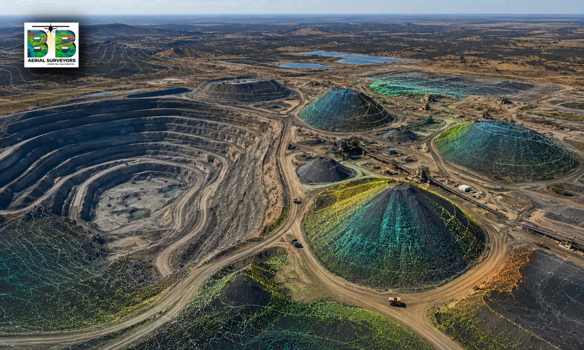
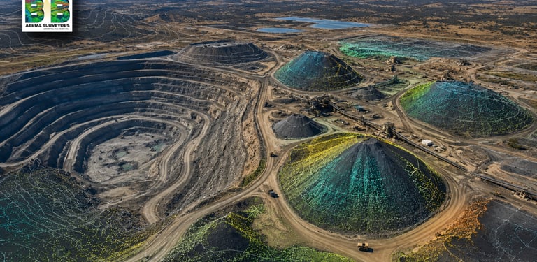
Aerial LiDAR can improve mining and volumetric surveys by capturing accurate 3D data across large or complex sites. This data can then be used to support stockpile measurements, terrain models, surface analysis, haul road planning and engineering-grade survey outputs.
BB Aerial Surveyors provides Mining & Volumetric Surveys using fixed-wing LiDAR and aerial mapping solutions for mining, infrastructure, agriculture, energy and environmental projects across Southern Africa.
What are mining and volumetric surveys?
Mining and volumetric surveys are used to measure physical features and material volumes on mining or quarry sites.
These surveys can support:
Stockpile volume calculations
Open-pit terrain mapping
Quarry mapping
Excavation monitoring
Haul road planning
Surface change monitoring
Mine expansion planning
Rehabilitation planning
Reporting and reconciliation
The purpose is to give mining teams reliable spatial data that helps them understand the site, track changes and make better operational decisions.
Why accurate stockpile data matters?
Stockpile data plays an important role in mining, quarrying and material management.
Accurate stockpile information can help teams understand:
How much material is available
How stockpile volumes are changing
Whether production and removal volumes align
Where material is located on site
How site conditions are changing over time
Whether reporting and planning are based on reliable measurements
Inaccurate stockpile data can create uncertainty in planning, reporting and decision-making. Better survey data helps reduce that uncertainty.
How LiDAR improves stockpile data?
LiDAR captures detailed 3D information about surfaces, terrain and physical features. When used for stockpile measurement, this data helps create a more accurate representation of the stockpile shape and surrounding ground conditions.
LiDAR can support stockpile data by helping teams:
Measure stockpile shape and height
Capture surface detail across the stockpile
Create terrain and surface models
Compare stockpile changes over time
Support volume calculations
Map surrounding site conditions
Reduce reliance on rough visual estimates
Provide consistent data for reporting
For larger or more complex mining sites, aerial LiDAR can capture wide areas efficiently while still producing technical survey outputs.
Why aerial LiDAR is useful for mining sites?
Mining sites often cover large areas and may include changing terrain, stockpiles, haul roads, slopes, pits, processing areas and access routes.
Aerial LiDAR is useful because it can help capture:
Large mining areas
Multiple stockpile zones
Open-pit terrain
Haul roads
Surface changes
Difficult-to-access areas
Surrounding terrain and drainage patterns
Areas where ground access may be slower or less practical
For mines and quarries where speed, coverage and accurate spatial data matter, aerial LiDAR can be a valuable survey method.
Fixed-wing LiDAR for large mining areas.
Fixed-wing LiDAR is especially useful when the survey area is large or spread across a wider mining environment.
It can support projects where the site includes:
Large open areas
Multiple stockpiles
Long haul roads
Remote sections of site
Changing terrain
Expansion areas
Rehabilitation zones
Surrounding land and infrastructure
Fixed-wing aerial mapping can provide the scale needed to understand the full site context, not only isolated stockpile locations.
What deliverables can come from a mining volumetric survey?
The final deliverables depend on the project scope and technical requirements.
Mining and volumetric survey deliverables may include:
LiDAR point cloud data
Digital terrain models
Digital surface models
Stockpile volume calculations
Contour data
Orthophotos
3D terrain models
GIS-ready datasets
Surface change data
Engineering-grade survey outputs
Reporting maps and visuals
These outputs can support engineers, mine planners, survey teams, project managers and operations teams.
Mining surveys beyond stockpiles.
Stockpile measurement is an important use case, but mining survey data can support more than volume calculations.
LiDAR and aerial mapping can also assist with:
Pit mapping
Haul road planning
Drainage and terrain assessment
Access route planning
Mine expansion studies
Environmental planning
Rehabilitation monitoring
Infrastructure planning around the mine
Surface condition assessment
This makes aerial LiDAR useful across different stages of a mining project.
When should a mining site consider aerial LiDAR?
A mining or quarry operation should consider aerial LiDAR when it needs accurate spatial data across a large, complex or changing site.
It may be useful when:
Stockpile volumes need to be measured
The site covers a large area
Terrain is changing regularly
Ground access is difficult or time-consuming
Multiple stockpiles need to be captured
Terrain models are required
Mine planning needs updated data
Environmental or rehabilitation planning is required
The data must support technical or engineering decisions
The earlier reliable survey data is available, the easier it becomes to make informed planning and operational decisions.
How mining teams use volumetric survey data?
Different teams may use volumetric survey data in different ways.
For example:
Operations teams may use it for production and material planning.
Mine planners may use it for future site layout and expansion planning.
Engineering teams may use it for terrain and infrastructure planning.
Environmental teams may use it for rehabilitation and compliance-related planning.
Management teams may use it for reporting and decision-making.
The value of the data increases when it is accurate, repeatable and easy to integrate into planning workflows.
How LiDAR supports better project decisions.
LiDAR does not only create a map. It helps convert physical site conditions into usable data.
For mining and volumetric surveys, this can help teams:
Reduce uncertainty
Improve site visibility
Support volume reporting
Track surface changes
Improve planning confidence
Identify terrain constraints
Reduce reliance on assumptions
Work from consistent spatial data
For large mining, quarrying or material handling environments, this can make survey data more useful across planning, operations and management.
Frequently Asked Questions
What is a volumetric survey?
A volumetric survey measures the volume of material or terrain features, such as stockpiles, excavations, pits or earthworks.
Can LiDAR measure stockpile volumes?
Yes. LiDAR data can be used to support stockpile volume calculations by capturing detailed 3D information about the stockpile surface and surrounding ground.
Is aerial LiDAR useful for mining sites?
Yes. Aerial LiDAR is useful for mining sites where large areas, multiple stockpiles, changing terrain or engineering-grade survey data are required.
What information is needed before requesting a mining survey quote?
Useful information includes the site location, approximate area size, number of stockpiles, required deliverables, accuracy requirements, timeline and intended use of the data.
Can LiDAR help with mine rehabilitation planning?
Yes. LiDAR can support terrain modelling, surface condition assessment and change monitoring, which can be useful for rehabilitation and environmental planning.
Is fixed-wing LiDAR suitable for large mine sites?
Yes. Fixed-wing LiDAR is well suited to larger mine sites, quarry areas and wide-area terrain mapping where scale, speed and coverage are important.
Need accurate mining and volumetric survey data?
BB Aerial Surveyors provides fixed-wing LiDAR and aerial mapping solutions for mining, infrastructure, energy, agriculture, environmental and development projects across Southern Africa.
If your project requires stockpile volume data, terrain modelling or engineering-grade survey outputs, speak to our team about your site and required deliverables.
Contact BB Aerial Surveyors to discuss your mining and volumetric survey requirements.
Contact Us
info@bbaerialsurveyors.co.za
+27-82-852-4309
© 2026 BB Aerial Surveys (Pty) Ltd. All Rights Reserved | Website designed and developed by Creative Co-Pilot — Guiding brands from idea to launch, and beyond.
LiDAR You Can Build On
Serving South Africa & Pan-Africa
Build Smarter With LiDAR
Get expert LiDAR updates, case studies, and project insights straight to your inbox.