
Route Selection and Feasibility Studies: Why Survey Data Matters Early
Route Selection and Feasibility Studies: Why Survey Data Matters Early
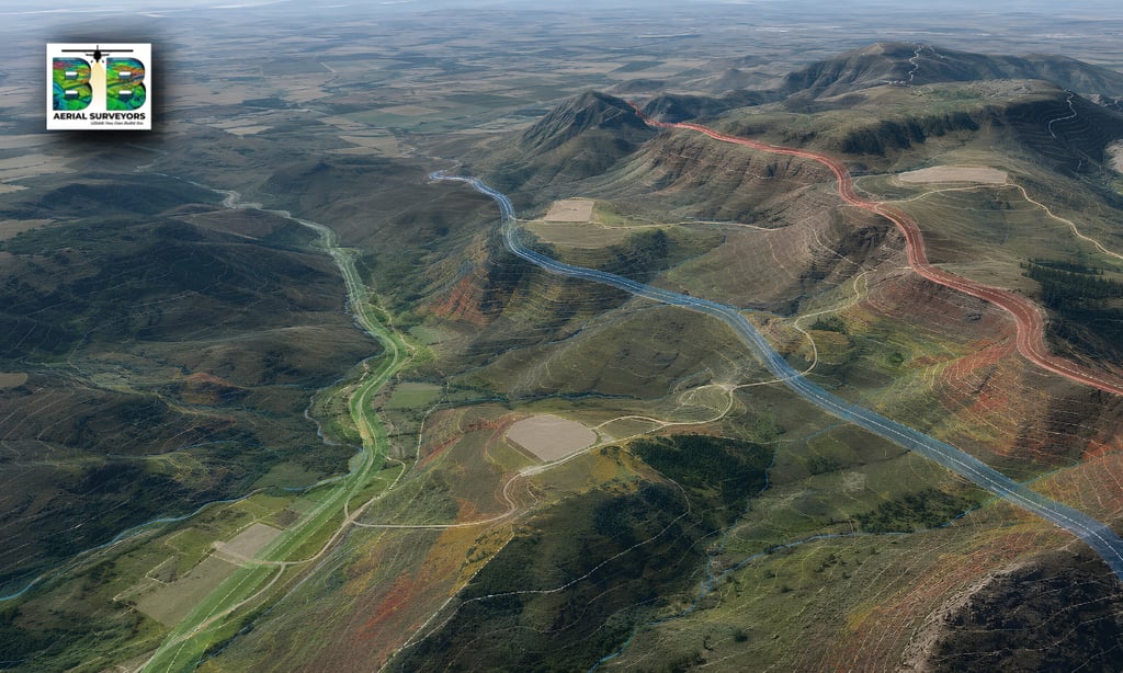
Route selection and feasibility studies are important early steps in many infrastructure, development, energy, mining and environmental projects.
Before a road, pipeline, powerline, access route, guest house development, mine expansion or infrastructure corridor is designed, project teams need to understand the land. They need to know where the terrain is suitable, where risks may exist, how access can be planned, and which areas may be more difficult or expensive to develop.
This is where accurate survey data becomes valuable.
Aerial LiDAR survey data can help project teams understand terrain, elevation, slopes, vegetation, access constraints and possible route options before major design or construction decisions are made.
BB Aerial Surveyors provides Route Selection & Feasibility Studies using fixed-wing LiDAR and aerial mapping solutions for infrastructure, energy, mining, agriculture, environmental and development projects across Southern Africa.
What is route selection?
Route selection is the process of comparing possible routes before choosing the most suitable alignment for a project.
This may apply to:
Roads
Access roads
Powerlines
Transmission corridors
Pipelines
Rail routes
Water infrastructure
Mine access routes
Development roads
Service routes
Environmental or agricultural access routes
The goal is to understand which route makes the most sense based on terrain, access, constructability, risk, cost, environmental impact and future use.
What is a feasibility study?
A feasibility study helps determine whether a proposed project or route is practical before detailed design or construction begins.
For land, infrastructure and development projects, feasibility studies often consider:
Terrain conditions
Elevation changes
Slopes and gradients
Access possibilities
Drainage and water movement
Vegetation cover
Existing infrastructure
Buildable areas
Environmental constraints
Engineering risks
Potential construction challenges
Good feasibility data helps project teams make better decisions earlier.
Why survey data matters early?
Survey data is most valuable when it is available before major decisions are locked in.
If route selection or development planning is done using limited information, teams may later discover problems such as:
Steep or unsuitable gradients
Difficult access routes
Poorly selected development areas
Unexpected terrain constraints
Drainage or water-flow issues
Higher construction complexity
Route changes during design
Delays caused by incomplete information
Increased costs due to avoidable planning mistakes
Accurate survey data helps reduce these risks by giving teams a clearer understanding of the project area from the start.
How LiDAR supports route selection.
LiDAR is useful for route selection because it captures detailed 3D information about the land surface, terrain shape, vegetation and elevation changes.
This helps project teams compare route options more effectively.
LiDAR survey data can support:
Terrain modelling
Slope and gradient analysis
Access road planning
Route alignment review
Buildable area identification
Elevated viewpoint assessment
Drainage and water-flow understanding
Vegetation and ground-surface analysis
Engineering and architectural planning
Early-stage project feasibility decisions
For difficult terrain, wooded land or mountainous areas, LiDAR can be especially useful because it can help create a more accurate model of the ground surface beneath vegetation.
Route selection for infrastructure projects.
Infrastructure projects often involve long routes, changing terrain and multiple technical constraints.
LiDAR survey data can assist project teams planning:
Roads
Rail routes
Pipelines
Powerlines
Transmission corridors
Water pipelines
Service routes
Access roads
Utility infrastructure
Renewable energy access routes
For these projects, early route selection data can help identify practical alignments, avoid unsuitable areas and support engineering teams during planning and design.
Feasibility studies for land development.
Survey data is also valuable for private land development, estates, lodges, guest houses, tourism sites, agricultural developments and property planning.
For landowners, developers, architects and engineers, LiDAR data can help identify:
Suitable development areas
Possible guest house or lodge sites
Elevated viewpoints
Buildable plateaus
Road and access route options
Terrain gradients
Steep or difficult areas
Areas requiring further engineering input
Service route possibilities
Drainage and water-flow considerations
This makes LiDAR useful before layout planning, architectural concept design or infrastructure planning begins.
Why LiDAR is useful in wooded or mountainous terrain?
Wooded and mountainous terrain can be difficult to assess from ground visits or normal aerial images alone.
Vegetation may hide the true shape of the ground, and steep slopes can make access difficult.
LiDAR survey data can help by providing:
More accurate ground-surface modelling
Terrain contours
Slope information
Elevation data
Access route insight
Buildable-area context
Better understanding of difficult terrain
This can help project teams avoid making decisions based only on what is visible from the surface.
Fixed-wing LiDAR for larger feasibility areas.
Fixed-wing LiDAR is useful when the project area is large, remote, complex or spread across long distances.
It can support feasibility and route planning for:
Long corridors
Regional development areas
Remote land parcels
Mining expansion zones
Large farms or estates
Mountainous terrain
Powerline and pipeline routes
Road and rail planning areas
Environmental planning areas
For projects where scale and terrain complexity matter, fixed-wing aerial LiDAR can provide the wider context needed for early-stage planning.
What deliverables can support route selection and feasibility?
The final deliverables depend on the project requirements, but route selection and feasibility survey outputs may include:
LiDAR point cloud data
Digital terrain models
Digital surface models
Contours
Orthophotos
Elevation profiles
Slope information
Route alignment data
GIS-ready datasets
Terrain models
3D mapping outputs
Engineering-grade survey data
Development planning maps
These deliverables can support engineers, architects, developers, planners, environmental consultants, GIS teams and project managers.
When should survey data be captured?
Survey data should ideally be captured as early as possible in the project planning process.
It is especially useful during:
Pre-feasibility
Feasibility studies
Land assessment
Route option comparison
Development planning
Environmental planning
Concept design
Tender preparation
Engineering design
The earlier the project team understands the land, the better the planning decisions can be.
Who uses route selection and feasibility survey data?
This type of data is commonly used by:
Engineering consultants
Architects
Landowners
Property developers
Infrastructure planners
Renewable energy developers
Mining companies
Environmental consultants
Municipal teams
Project managers
GIS specialists
Construction planners
Each team may use the data differently, but the purpose is the same: to make better decisions before design and construction begin.
How better survey data can reduce project risk
Route and feasibility decisions affect cost, design, access, infrastructure layout and long-term project success.
Better survey data can help reduce risk by:
Identifying unsuitable areas earlier
Supporting better route alignment
Highlighting access challenges
Reducing reliance on outdated maps
Improving design confidence
Helping architects and engineers work from accurate terrain data
Supporting more informed discussions with stakeholders
Reducing avoidable changes later in the project
For complex land, large sites or long routes, accurate survey data can be one of the most useful early planning tools.
Frequently Asked Questions
What is route selection in surveying?
Route selection in surveying is the process of using accurate spatial data to compare possible route options for roads, pipelines, powerlines, access roads or infrastructure corridors.
How does LiDAR help with feasibility studies?
LiDAR helps by providing accurate terrain, elevation, slope and surface data that can support early planning, route comparison, access planning and development feasibility decisions.
Can LiDAR help identify buildable areas?
Yes. LiDAR can help project teams understand terrain shape, gradients and elevation, which can support the identification of areas that may be more suitable for development.
Is LiDAR useful for wooded or mountainous land?
Yes. LiDAR can be useful in wooded or mountainous terrain because it helps model the ground surface and understand elevation, slope and terrain conditions more clearly.
What information is needed before requesting a route selection survey quote?
Useful information includes the project location, approximate area size or route length, intended development type, required deliverables, timeline and intended use of the survey data.
When should route selection survey data be captured?
Route selection survey data should be captured early, ideally during pre-feasibility, feasibility, concept planning or before detailed design begins.
Need survey data for route selection or feasibility planning?
BB Aerial Surveyors provides fixed-wing LiDAR and aerial mapping solutions for infrastructure, energy, mining, agriculture, environmental and development projects across Southern Africa.
If your project requires terrain data, route planning, feasibility input, contour information or engineering-grade survey outputs, speak to our team about your project area and required deliverables.
Contact BB Aerial Surveyors to discuss your route selection and feasibility survey requirements.
Contact Us
info@bbaerialsurveyors.co.za
+27-82-852-4309
© 2026 BB Aerial Surveys (Pty) Ltd. All Rights Reserved | Website designed and developed by Creative Co-Pilot — Guiding brands from idea to launch, and beyond.
LiDAR You Can Build On
Serving South Africa & Pan-Africa
Build Smarter With LiDAR
Get expert LiDAR updates, case studies, and project insights straight to your inbox.